🍽
Fresh Catch
Grilled perfectly.
"Discover the authentic beauty of Ikaria."
According to tradition, it derives its name from Icarus, the son of Daedalus in Greek mythology, who was believed to have fallen into the sea nearby and to have been buried on the island.
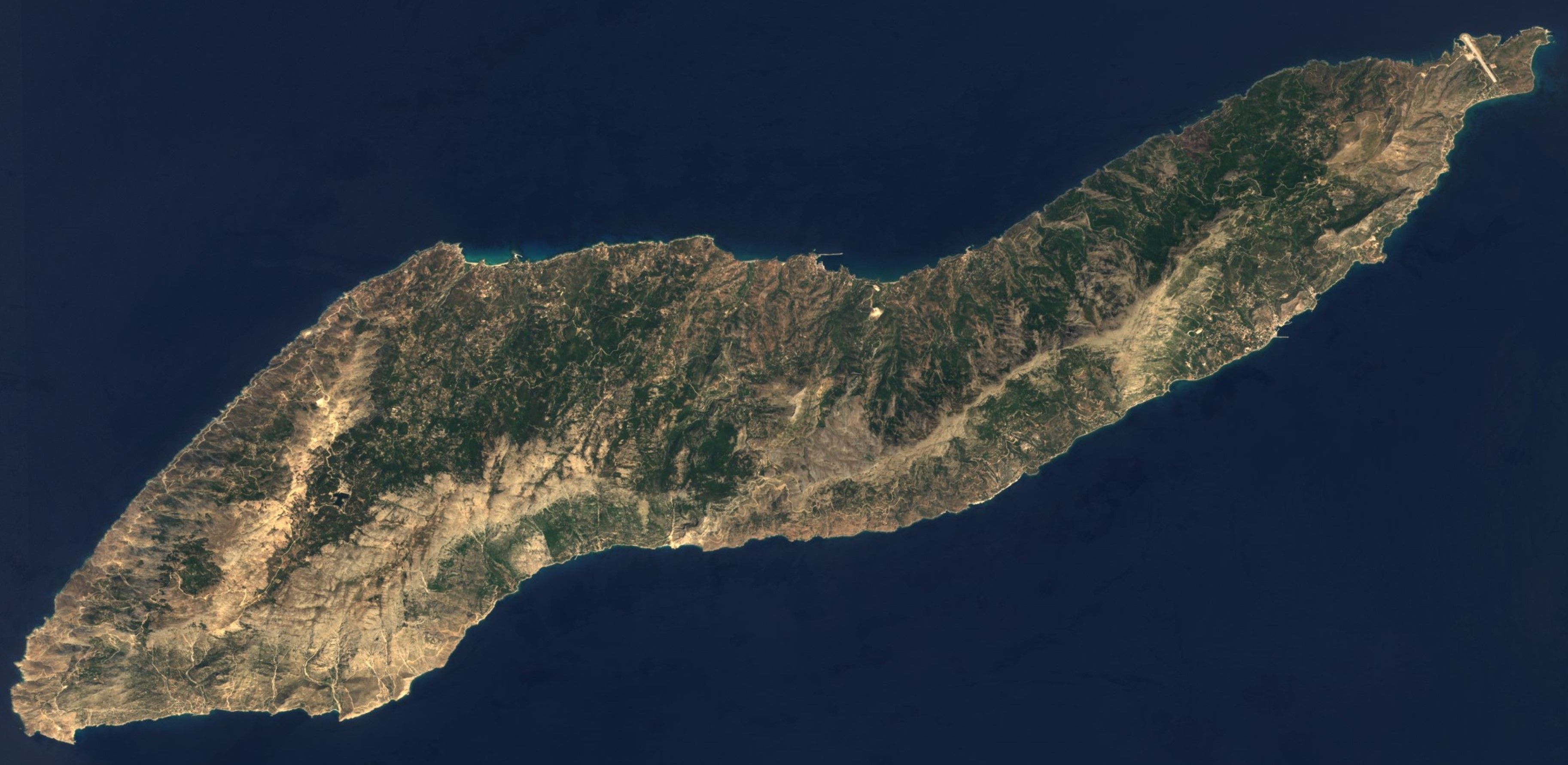
The topography contrasts between verdant slopes and barren steep rocks. The island is mountainous for the most part. The entire island is crossed east-west by the Aitheras (Αιθέρας) mountain range, whose highest summit stands at 1,037 metres (3,402 feet) and splits the island between north and south. The north side tends to be greener and more fertile, predominantly hilly and increasingly mountainous towards the south, with large forests of mainly aleppo pine and oak, with very few olive trees. The south tends to be rockier, drier and with harsher terrain, with steep cliffs towering several hundred meters above the sea. The central part of the island, called Mesaria by the locals (roughly the same area covered by Evdilos prefecture), is its most fertile area and the ancient centre of the island. To the west of it lies the Raches region and its villages, the island's most popular region amongst visitors for its traditional settlements and cultural events.
Ikaria has been inhabited, according to archaeological findings in the central and eastern parts of the island, since at least 7000 BC, when it was populated by the Neolithic Pelasgians, a blanket term used by the ancient Greeks to refer to all pre-Hellenic peoples inhabiting the Greek region. Greeks from Miletus, a major Greek polis and naval power of Asia Minor, colonized Ikaria around 750 BC, establishing their settlement in the area of present-day Kampos, the fertile, comparatively low-lying region in the north-central part of the island, which later became the ancient capital city of Oenoe. Later tradition names four major cities to have sprung on the island, Oenoe, Thermae, Drakanon (now Faros) and Tauropolion (now Nas).
Research Note
Part of our exhaustive 2026 Golden Guide archive for Ikaria. Verified by local historians and environmental researchers.
The temple stood in good condition until the mid-19th century, when the marble was pillaged by local villagers to procure building materials for their local church. This church was excavated by Greek archaeologist Leon Politis in 1939. During the Axis occupation of Greece, many of the artifacts unearthed by Politis disappeared, with local tales claiming that the occupiers looted them. According to local legend, marble artefacts from the temple still lie under the sand of the Nas beach where the temple stood.
The Archaeological Museum, located in the village of Kampos, stands on the hill where ancient Oenoe also stood, and is immediately next to Agia Irini, the island's oldest standing church. The museum contains over 250 artifacts, including Neolithic tools, pottery vessels, clay statuettes, columns, coins, and carved headstones.
Research Note
Part of our exhaustive 2026 Golden Guide archive for Ikaria. Verified by local historians and environmental researchers.
The topography contrasts between verdant slopes and barren steep rocks. The island is mountainous for the most part. The entire island is crossed east-west by the Aitheras (Αιθέρας) mountain range, whose highest summit stands at 1,037 metres (3,402 feet) and splits the island between north and south. The north side tends to be greener and more fertile, predominantly hilly and increasingly mountainous towards the south, with large forests of mainly aleppo pine and oak, with very few olive trees. The south tends to be rockier, drier and with harsher terrain, with steep cliffs towering several hundred meters above the sea. The central part of the island, called Mesaria by the locals (roughly the same area covered by Evdilos prefecture), is its most fertile area and the ancient centre of the island. To the west of it lies the Raches region and its villages, the island's most popular region amongst visitors for its traditional settlements and cultural events.
Most of Ikaria's population, both of its main towns and several of its larger villages are nestled on or near the coast. The principal town of the island, main port and seat of the municipality is Agios Kirykos. Evdilos follows in importance, the historic main city of the island (and a short distance from the ancient chief town of Oenoe) containing the island's secondary port, servicing the north side. Agios Kirykos and Evdilos are the only two ports serviced by passenger ferries, making them Ikaria's main transport links to the rest of Greece.
In antiquity, the island was called Icaria or Ikaria (Ancient Greek: Ἰκαρία) by the ancient Greeks, the same as today, as it was believed the mythical Icarus fell into the sea south of the island on his flight from Crete. The name, however, may have instead come from the Phoenician word for fish (ikor) or for sheep (kara), in either case implying an abundance of natural life. Other historical (and now unused) names in Greek are Dolichi (Δολίχη) or Dolychi (Δολύχη), Makri (Μάκρη), Ichthyoessa (Ιχθυόεσσα) and Anemoessa (Ανεμόεσσα), the first two pertaining to the island's elongated shape and the latter two to its abundance of fish and harsh winds, respectively.
Research Note
Part of our exhaustive 2026 Golden Guide archive for Ikaria. Verified by local historians and environmental researchers.
Without a decent port – most having been destroyed by the islanders themselves for protection against piracy – Ikaria depended for its very limited trade with the outside world upon small craft that were drawn up on the beaches. Ikarian boat-makers had a good reputation for building boats from the island's fir forests, selling both the boats and lumber for coin and grain in nearby Chios. The inshore waters of the island, as told by Georgirenes, provided the best cockle shellfish in the entire archipelago. Over the centuries, Ikaria would also become renowned for its charcoal, which became known as Carbon Cariot (Ikarian Charcoal). Ikaria in the 17th century was unusual in the archipelago in not producing any wine for export, the locals keeping barrels of the strong red wine for themselves. They also continued to store it in the way prevalent since the Bronze Age, in terracotta pithoi containers sunk to their rims in earth, thus protecting their supplies from both tax collectors and pirates. Flocks of goats and sheep, even those belonging to shepherds, ranged free and virtually untended in the rocky highlands, much like today. Cheese was made for consumption in every household.
The Free State of Ikaria (Ελευθέρα Πολιτεία Ικαρίας, Elefthéra Politía Ikarías) was declared on 18 July 1912. The neighboring islands of Fournoi Korseon were also incorporated in the Free State. Doctor Ioannis Malachias (Ιωάννης Μαλαχίας) was the first and only president of the Free State. After the outbreak of the First Balkan War in October 1912, Ikaria's sole "warship", the Cleopatra, was used to provide food and supplies to the islands of Samos and Chios, captured by the Greek Navy in the war's Aegean campaign.
Ikaria remained an independent country for five months, with its own government, armed forces, national flag, coat of arms, postage stamps, and national anthem. These five months were difficult for the island's economy, with food shortages and the risk of being annexed into the Italian Dodecanese. On 4 November 1912, after a delay due to the Balkan Wars, Ikaria officially became part of the Kingdom of Greece. The Ottoman Empire recognized Greece's annexation of Ikaria and the other Aegean islands in the Treaty of London (1913).
Research Note
Part of our exhaustive 2026 Golden Guide archive for Ikaria. Verified by local historians and environmental researchers.
This frugal way of living contributed to the famed Ikarian longevity and the absence of distinct social classes. Despite the existence of villages, every house was its own self-sufficient entity, using the living space around it for the cultivation of all necessary things. Women contributed freely in work and social life. Villages were slowly created by descendants of an original family which gradually spread. Despite the sparse population, societal cohesion was high. There were the panigyria (traditional festivals, common across Greece, featuring dances, music and consumption of local products), team labour and elder councils who were in charge of taking important decisions. This unique way of life and architecture was preserved until the end of the 19th century, with many elements surviving until today; most famously the panigyria, which are still some of the largest of all the Aegean islands.
Research Note
Part of our exhaustive 2026 Golden Guide archive for Ikaria. Verified by local historians and environmental researchers.
The dishes that define this place
Grilled perfectly.
Artisan made.
Foraged daily.
Explore the ancient pathways.
A pristine spot away from the crowds.
Unmarked history.
Curated by locals, organised by depth
Watch the sun dip below the Aegean.
Find Hotels in Ikaria, Greece
via Booking.com — free cancellation on most rooms
Affiliate link — we earn a small commission at no extra cost to you
